We use cookies to ensure our site functions properly and to store limited information about your usage. You may give or withdraw consent at any time. To find out more, read our privacy policy and cookie policy.
Manage Cookies
A cookie is information stored on your computer by a website you visit. Cookies often store your settings for a website, such as your preferred language or location. This allows the site to present you with information customized to fit your needs. As per the GDPR law, companies need to get your explicit approval to collect your data. Some of these cookies are ‘strictly necessary’ to provide the basic functions of the website and can not be turned off, while others if present, have the option of being turned off. Learn more about our Privacy and Cookie policies. These can be managed also from our cookie policy page.
Strictly necessary cookies(always on):
Necessary for enabling core functionality. The website cannot function properly without these cookies. This cannot be turned off. e.g. Sign in, Language
Analytics cookies:
Analytical cookies help us to analyse user behaviour, mainly to see if the users are able to find and act on things that they are looking for. They allow us to recognise and count the number of visitors and to see how visitors move around our website when they are using it. Tools used: Google Analytics
East Renfrewshire: A Connected Network of Climate-Ready Places
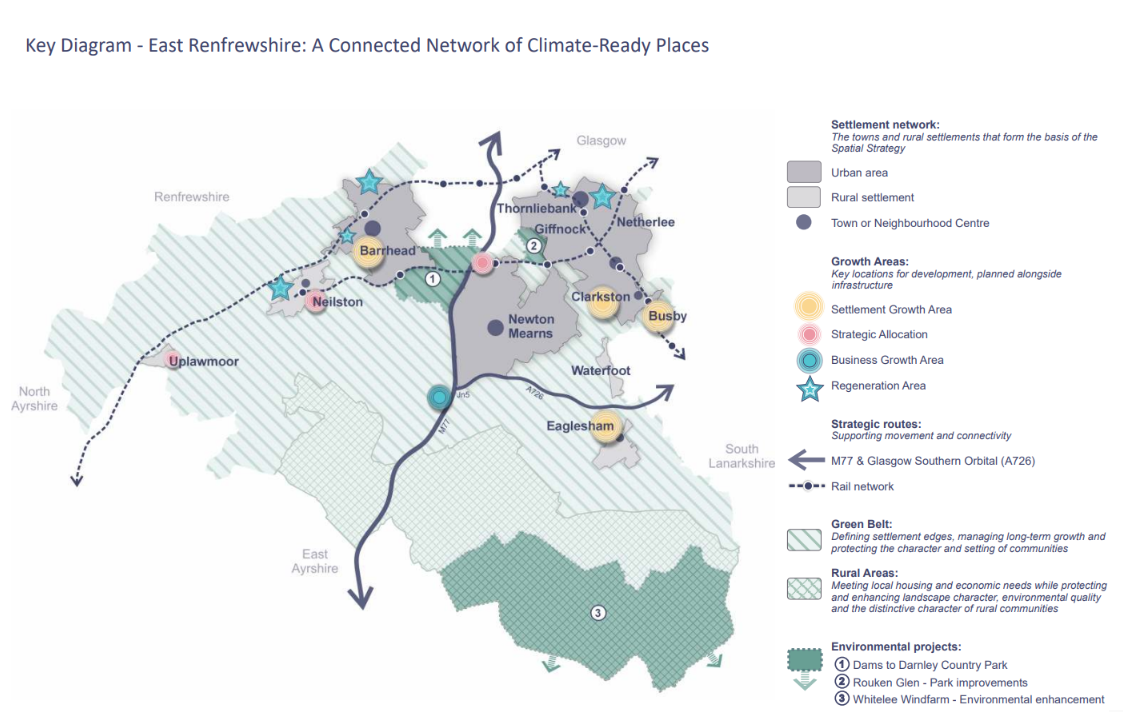
The Key Diagram illustrates the Spatial Strategy as a connected network of compact, climate‑ready places across East Renfrewshire. It highlights the relationship between settlements, Growth Areas, infrastructure corridors and the natural environment.
What the diagram shows:
Settlement network: the towns and villages that form the basis of the Spatial Strategy.
Growth Areas: key locations for development, planned alongside infrastructure.
Strategic routes: including the M77, Glasgow Southern Orbital and rail network, supporting movement and connectivity.
Green Belt and Rural Areas: defining settlement edges, managing long-term growth and protecting the character and setting of communities.
Symbols are indicative and do not represent precise site boundaries. Detailed allocations and land use designations are set out in the Proposals Map.
The Key Diagram illustrates the Spatial Strategy as a connected network of compact, climate‑ready places across East Renfrewshire. It highlights the relationship between settlements, Growth Areas, infrastructure corridors and the natural environment.
What the diagram shows:
Settlement network: the towns and villages that form the basis of the Spatial Strategy.
Growth Areas: key locations for development, planned alongside infrastructure.
Strategic routes: including the M77, Glasgow Southern Orbital and rail network, supporting movement and connectivity.
Green Belt and Rural Areas: defining settlement edges, managing long-term growth and protecting the character and setting of communities.
Symbols are indicative and do not represent precise site boundaries. Detailed allocations and land use designations are set out in the Proposals Map.